Today is the conclusion of
Tornado and Severe Weather Awareness Week in Wisconsin. Because Mother Nature apparently appreciates irony, we also have the
first prediction of potential severe weather of the year in northeast Wisconsin.
(Links before I resume, since these are our
tax dollars at work: If you are in Fond du Lac, Green Lake or Marquette counties, your forecast comes from
Sullivan; otherwise, your forecast comes from
Ashwaubenon. Severe weather information can be found
here. A projection of weather beyond this week can be found
for six to 10 days,
8 to 14 days,
one month and
three months.)
I have an odd fascination with severe weather (odd because, as my mother would no doubt tell you, severe weather provoked outsized anxiety in the much younger version of me, and because my worst subject in school was science). I haven’t ever gone storm-chasing (unlike a certain sales and editorial assistant I know), and I probably should be less fascinated seeing as how severe weather could provoke a confrontation between the two large trees on our lot and our house that no doubt would be expensive. Perhaps it’s that severe weather is a sign of spring and summer, which I find vastly preferable to winter.
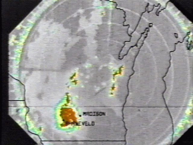
Growing up in Madison in the era before every TV station had its own color weather radar, I remember watching weather reports that included mention of “
Neenah radar,” a radar station that was in operation between 1972 and 1995. The Neenah weather radar station is gone (I believe the tower is still there, though, on what now is Neenah’s southwest side), as is the National Weather Service’s
Madison office, where a neighbor of ours used to work. Dane County, home of the People’s Republic of Madison, is one of two counties that has averaged
one tornado per year for the past 25 years.
Last June 7, the severe weather forecast was
a bit apocalyptic, to say the least. So when nothing (as in no weather at all other than high winds) happened in Fond du Lac County, I assumed the National Weather Service had messed up a forecast once again … that is, until I saw the coverage of the
tornado and storm damage in the northern part of the New North. Three years earlier, on June 23, 2004,
severe weather blew up pretty much
out of nowhere, including a tornado that sucked a man out of his basement and killed him near Markesan. (More detailed reading on that outbreak can be found
here.) And three years before that was a
hurricane-like storm that twisted road signs on U.S. 41, peeled back roofs on buildings near 41, and caused the water in Lake Winnebago to actually move into and out of lake homeowners’ back yards.
I don’t have evidence for this, but I believe the National Weather Service issues more tornado warnings than in past years, and that’s not necessarily a good thing. The old criteria for issuing a tornado warning was the sighting of a tornado by a spotter or a “
hook echo” on radar. Now, sufficient rotation in a severe thunderstorm, which can be detected by Doppler radar, will result in a tornado (or, as I call them, STCOPAT, for “Severe Thunderstorm Capable of Producing a Tornado”) warning.
The usual pattern is that when warnings don’t pan out, people ignore them until a warning does pan out and people die, after which the pendulum swings the other way. In the four days after the
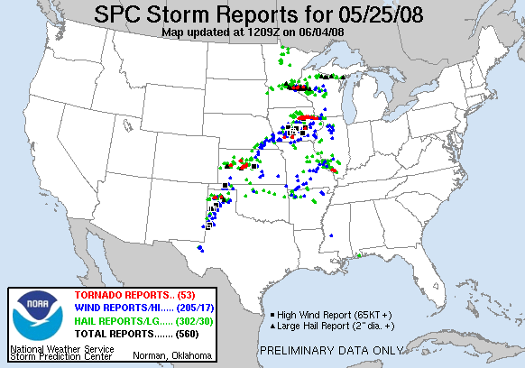
1984 Barneveld tornado, in which eight people died (because there was no tornado warning, since the
tornado formed just outside Barneveld in the middle of the night), two tornado warnings were issued, the first for a supposed tornado less than a mile away from our house in Madison. (That warning interrupted my brother’s high school graduation party; had there been a tornado, we would have seen it, and we didn’t.)
One July day in 1996, I stopped after work at a used bookstore in Appleton that had on its radio Wisconsin Public Radio, which was broadcasting tornado warnings for other parts of the state. When I checked out, the man at the cash register made a scoffing kind of remark about how the Weather Service usually gets forecasts wrong. But not that day, as people in
Oakfield discovered.
The Weather Service is, of course, a convenient target for jokes about their accuracy, or
lack thereof, in predicting weather. Then again, this state’s particular climate makes predicting weather difficult. This is, after all, the state that has had tornadoes in
January and
December, and has had snow in
May. Back in my weekly newspaper days, a tornado hit in the county where I was working one March afternoon. (My then-girlfriend, now wife, was visiting a client in the client’s mobile home, which of course is where one would prefer to not be when the tornado sirens activate.) That night, I covered a severe weather spotter training session not far from where the tornado hit, driving through blowing snow to get there. I’ve also had the experience of announcing that a tornado watch was in effect during a basketball game in November.
Wisconsin is not considered to be part of the famous
Tornado Alley, but Wisconsin does have its own
Tornado Alley, along U.S. 151 between Grant County and Fond du Lac; 151 goes either through or near most of the top counties for tornadoes in Wisconsin
since 1844. I grew up in Dane County (27 tornadoes since 1982), used to live in Grant (23 tornadoes) and Dodge (21 tornadoes) counties, and now live in Fond du Lac County (24 tornadoes), so even though I have never seen a tornado, I’m guessing it’s a question of when, not if.
 8:50 a.m. Update:
 The National Weather Service
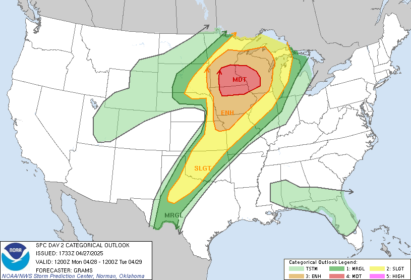
Storm Prediction Center places us in the "
Slight" risk area for severe weather today, which means a 5 to 25 percent chance of one or more instances of severe weather (hail of ¾ inch or larger, winds of 58 mph or more, and tornadoes) within 25 miles of any point within the “Slight” area (see the top map). More specifically, as of 8 a.m. there is a
2 percent chance of a tornado within 25 miles of any point (second map)

, a
15 percent chance of hail of ¾-inch hail within 25 miles of any point (third map), and a
15 percent chance of winds of 50 knots, or 58 mph, within 25 miles of a point

(bottom map). Interestingly, heavy rain or lightning don’t fit into the Weather Service’s definition of severe weather, given that flooding and lightning are
first and second on the list of storm-related causes of death.
 12:40 p.m. Update:
 The tornado threat has increased to
5 percent in southwest and south central Wisconsin and remains 2 percent for essentially everyone south of a curve from Green Bay to La Crosse. The Weather Service will update these maps again at 3 p.m.
2:50 p.m. Update: The National Weather Service has issued
this Tornado Watch for, in the Marketplace circulation area, Fond du Lac, Green Lake, Marquette, Sheboygan, Waushara and Winnebago counties (which covers both my office and my house) until 8 p.m. A line of severe thunderstorms is developing from Lone Rock southward into Missouri, moving northeast around 40 mph. The Storm Prediction Center has increased the tornado threat to
10 percent within the watch area.
Evening update: Since I went to De Pere for an interview at 4:45, I missed all of this:
- 4:28: A severe thunderstorm warning for Fond du Lac County until 5:30.
- 4:30: A severe thunderstorm warning for Marquette and Green Lake counties until 5:30.
- 5:00: A severe thunderstorm warning for eastern Fond du Lac and western Sheboygan counties until 5:45.
- 5:04: The Weather Service expects hail to 2 inches diameter, 70 mph winds and tornadoes from the storms affecting "all of south central and southeast Wisconsin."
- 5:34: Tornado warning for Green Lake County until 6:15 for a STCOPAT near Pardeeville moving northeast at 44 mph.
- 5:37: "Trained weather spotters" spot a tornado near Dalton moving northeast at 46 mph.
- 5:48: The cats in our house are freaked out by the weather radio and sirens going off for a tornado warning for southern Green Lake and northwestern Fond du Lac counties until 6:30. The "strong tornado" is near Markesan moving northeast at 53 mph; it's expected to be in Ripon by 6:05.
- 5:55: The sky in Ripon is reported to be an aquamarine color. Bad sign.
- 5:57: Back at the Menasha nerve center, a severe thunderstorm warning is in effect for northwestern Calumet, northeastern Winnebago and southern Outagamie counties until 6:45, for a line of storms from Oshkosh to Menasha moving northeast at 45 mph.
- 5:58: The tornado is supposed to be near Fairwater heading toward West Rosendale and Rosendale. But around this time, a funnel cloud is seen above Ripon's south side (though not by me, since at this moment I'm noticing how dark it's getting in De Pere).
- 6:11: The Fox Cities-area storm is now in Mackville heading northeast. Winds of 60 mph have been reported at the Outagamie County Airport and in Combined Locks.
- 6:14: Tornado now sighted near Wiota, southeast of Ripon, moving toward Rosendale.
- 6:20: The 5:57 severe thunderstorm warning is cancelled because the storm has moved out of the area. However ...
- 6:22: Tornado warning issued for eastern Winnebago and southwestern Calumet counties until 6:45, for a STCOPAT nine miles southwest of Oshkosh heading toward Oshkosh at 47 mph.
- 6:28: Rotating wall cloud (from whence come tornadoes) sighted five miles southwest of Oshkosh heading toward Oshkosh.
- 7:37: Tornado watch cancelled.
Today's storm report for Wisconsin: One tornado near Wyocena; hail reported in, in chronological order, Waukesha, Juneau, Adams, Sauk, Dodge, Columbia, Portage, Wood, Green Lake, Winnebago, Marathon, Fond du Lac, Lincoln, Oneida and Vilas counties; high winds reported in Grant, Outagamie (three trees downed in Appleton), Brown (uprooted trees in Green Bay), Kewaunee and Waukesha counties. Either the Weather Service gets an A for today, or the weather cooperated with their forecast. (No, I am not going to do this for every instance of possible severe weather this spring and summer.)
Postscript: Around 7:50 p.m. a woman called WIXX to say that she called her house and told her husband to turn off all the electrical appliances in their house because there was a tornado warning. The husband replied: "A tornado warning? I'm going to get my camera!"
The last thing the woman said: "I'm going back on the Pill."
 You may have observed they have an annoying tendency to be accurate these days.
 The line from the Milwaukee/Sullivan weather office’s Hazardous Weather Outlook gives one pause: “Spotter activation may be needed through Friday evening.”

